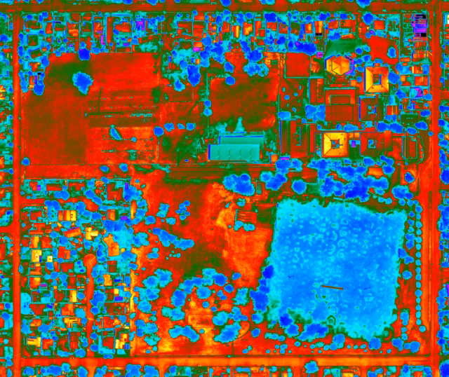
Visual intelligence for portfolio and asset management

Delivering data-driven visual insights

Asset managers require accurate, up-to-date visual documentation to support investment decisions and portfolio monitoring. Sky Monkey provides comprehensive aerial photography, inspection documentation, and analytical visual content for real estate portfolios, infrastructure assets, and development projects. From property valuations and compliance documentation to progress tracking and strategic planning, our drone services deliver high-quality visual intelligence that informs better asset management decisions and maximises investment returns.

A split-screen 3D model of a large building complex, showing a gray-scale mesh geometry on the left and a full-color textured aerial view on the right.

Services

Services typically utilised by Asset Managers

Here are typical services utilised by Asset Managers. Services are often combined to provide a more complete solution. Simply contact us to discuss about your ideas and tell us what you’d like to acheive.

  • Thermal Inspection

    We utilise infrared technology to detect hidden defects that standard RGB visuals cannot identify. Our aerial thermal inspections equip asset managers with sub-surface issues before they lead to costly failures or safety hazards.

    Thermal aerial map of parklands and a housing block in South Dubbo, NSW, Australia.
  • Compliance

    We provide expert guidance on CASA regulations, flight approval and safety management. We ensure your drone operations remain fully compliant, insured, and safe.

    Wash drone geraldo crp compliance skymonkey
  • Heavy Industrial Applications

    Showcase the ever-evolving landscape of large-scale projects. We specialise in aerial solutions for heavy industry, from monitoring site updates to capturing the full spectrum of the construction process. We deliver high-impact results and technical aerial solutions tailored to your project’s needs.

    An aerial drone photograph of a mining site featuring a yellow Volvo excavator loading earth into a large yellow dump truck amidst rocky terrain and forest.
  • Dilapidation & Defect Survey

    Comprehensive detailed visuals for critical assets. We specialise in curating high resolution visuals in hard to reach areas to identify critical defects of your assets.

    A close-up inspection photograph showing heavy orange rust corrosion and staining on a metal support beam and perforated panel attached to a white concrete ledge.
  • Photogrammetry

    We capture thousands of data points to generate millimetre accurate models of your asset. The interactive model allow for remote measurements, site progress, and visual walkthroughs from anywhere in the world.

    A detailed 3D photogrammetry model of an abandoned, multi-story Victorian-style building with a complex red-tiled roof, green wooden balconies, and weathered white walls against a black background.
  • DA Viewline Analysis

    Eliminate the guesswork for your next project. Development applications require more than just a photo. It requires accuracy. Capturing exact heights and view lines, we help you demonstrate your proposals with absolute confidence.

    Drone photo of Sydney Harbour facing the north from Barangaroo, using the Sony A7R4 61mp full frame camera, lifted by a heavy lifter drone by Sky Monkey

Asset Managers we currently serve

Reach out

Contact Us

Simply reach out to us online. Click on the button below. We will respond swiftly.

Creative photography at night using a long exposure professional camera of a drone flying in a spiral path, taken at Sydney Olympic Park Archery by Sky Monkey